Your Digital Dockets Still Have a Measurement Problem

Founder & CEO, Deep Purple AI Consulting
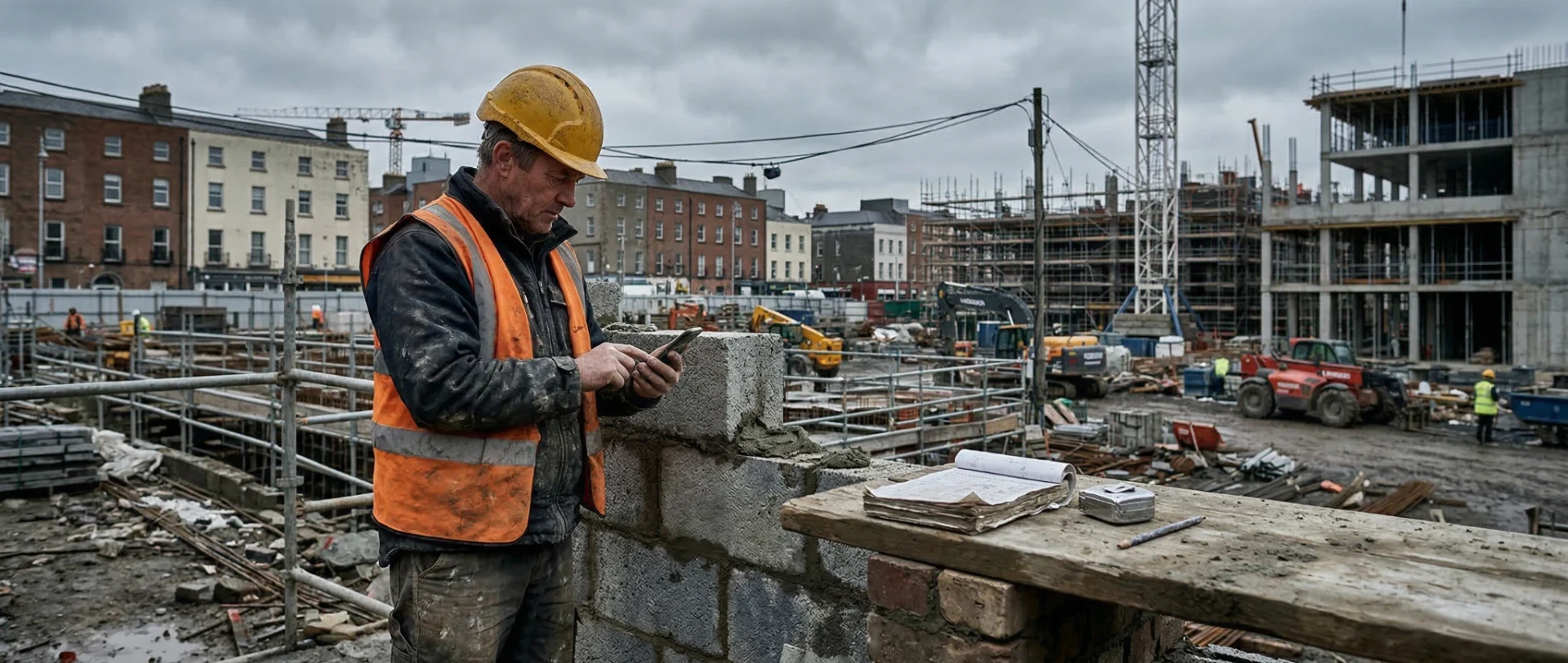
Irish construction firms are going digital. Paper docket books are disappearing. Apps are replacing triplicate forms. That is genuine progress.
But if the operative still measures with a tape and types the number into an app, how is the data any more accurate than it was on paper?
It is not. It is just faster.
We built a system that solves exactly this problem for an Irish construction contractor. The results are in the case study.
This article is about what changes when you stop digitising the measurement process and start verifying it instead.
Why Going Digital Is Not the Same as Getting Accurate Data
In measurement-heavy workflows, the problem is often not the form. It is that the number going into the form is still manual.
A digital docket with a wrong measurement is just a quicker record of the wrong number. The office gets it sooner. It is still wrong.
Digital dockets for construction in Ireland are becoming standard. That is the right direction. But digitising the form and verifying the content are two different things. Most of the tools on the market do the first. Almost none do the second.
What Digital Docket Apps Actually Do (And What They Do Not Do)
The Irish market now has several digital docket tools built for construction, plant hire, and haulage. They offer searchable records, timestamped entries, GPS-tagged submissions, photo capture, digital signatures, and compliance trails.
That is a big step up from a triplicate book in the back of a van.
But look at what happens with a measurement. An operative measures a completed area with a tape. They type the number into the app. The app records it, timestamps it, and sends it to the office.
If the operative measured wrong, the record is wrong. If the surface was irregular and the tape reading was rough, the record is rough. The app does not know. It records what it is told.
This is the gap. Digital docket tools digitise the form. They do not verify the content.
One other thing worth saying. Most of what people call "AI in construction" right now is document AI. Software that reads contracts, sorts documents, or generates safety reports. That is useful work, but it is a different problem. This article is about physical AI: measuring actual work in the field from photographs. Different problem. Different technology.
What Changes When the Measurement Is Verified
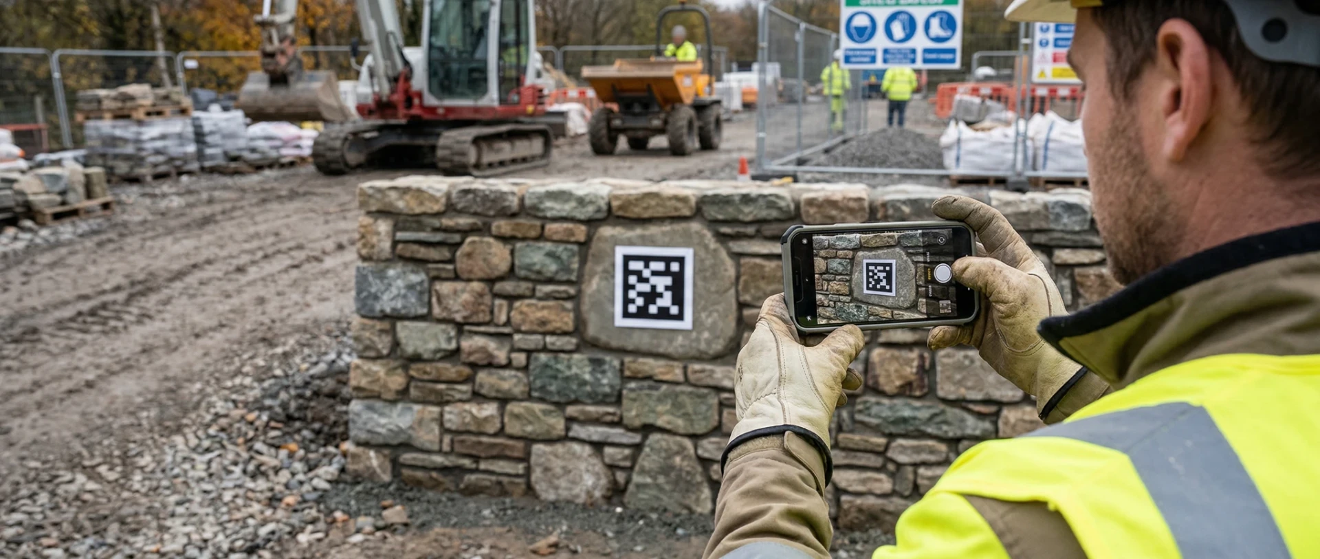
Instead of an operative reading a tape and typing a number, picture this. The operative photographs the completed work with their phone. A reference marker in the frame gives the system a known scale. The operative draws an outline on the screen with their finger. The system calculates the area from the photograph.
Three things change:
- Accuracy improves. A tape measure on an irregular surface carries 15–20% variance. That is what we measured when we compared tape readings against verified remeasurements on real Irish construction sites. A calibrated photograph gets that down to ±3%.
- The evidence is photographic and auditable. Every submission includes the photograph, the calculated area, GPS coordinates, and a timestamp. That is not a number someone typed. It is a verifiable record of what was there, when, and how much.
- Progress data updates in real time. Nobody in the office is chasing dockets. The data is in the system the moment the operative submits. The project dashboard updates automatically.
The office knows where every site stands at the end of every working day. Not at the end of the week. Not after reconciliation. Today.
How the Three Approaches Compare
| Paper Dockets | Digital Dockets | Verified Measurement | |
|---|---|---|---|
| Data delay | Days. Dockets arrive in batches, often a week late. | Minutes. Submitted from site instantly. | Minutes. Submitted and calculated instantly. |
| Measurement accuracy | 15–20% variance on irregular surfaces. | Same. The operative still types a tape reading. | ±3%. Calculated from a calibrated photograph. |
| Evidence quality | Handwritten number. No photo. No GPS. | Typed number with timestamp and GPS. | Photograph, GPS, timestamp, and calculated area. |
| Real-time visibility | None. Office sees data days later. | Partial. Office sees what was typed. | Full. Dashboard updates with every submission. |
| Site data quality | Low. Error-prone. Uncheckable. | Better format. Same underlying data quality. | Verified. The measurement is calculated, not estimated. |
Four Site Workflows Where Verification Matters Most
Where does this actually matter on a real construction site? Four workflows come up repeatedly.
Area measurement on irregular surfaces. This is the tape measure problem. Heritage stonework, earthworks, cladding, groundworks. Anything where the surface is not flat and the shape is not rectangular. A tape reading on a curved retaining wall is a rough estimate. A calibrated photograph gives you a number you can stand over.
Daily progress tracking across multiple sites. If you run six or seven active sites and your project managers need to know where each one stands, you have two options. Drive out and check. Or wait for the dockets to arrive. Verified photo submissions give you a third option: a dashboard that updates with every submission, across every site, without anyone driving anywhere.
Quality evidence from submitted photographs. When every submission includes a photograph of the completed work, someone in the back office can review the standard of work the same day. No site visit needed. Problems get caught early. The operative also sees their own output through a personal productivity dashboard.
Proof for billing. When payment is tied to quantities, the numbers need to be defensible. A timestamped, GPS-tagged, photo-evidenced, area-calculated submission is harder to dispute than a handwritten docket reconciled a week later. The commercial consequences of weak field measurement data are significant. We cover them in detail in a separate article on construction payment disputes.
When a Digital Docket Is Enough (And When It Is Not)
An Honest Assessment
Honesty matters here. Not every construction workflow needs verified field measurement.
If your dockets record deliveries, plant movements, or time on site, a digital docket app is probably enough. The data is straightforward. Going digital gives you searchable records, compliance trails, and faster processing. That is genuine value.
Verified measurement adds value in specific situations:
- When the accuracy of the measurement directly affects payment. Measured-works contracts, remeasurement contracts, anything where the QS will query quantities.
- When you need photographic evidence of completed work. For billing, for disputes, for client progress reports, for quality review.
- When you operate across multiple remote sites and need real-time visibility without relying on someone in the office chasing paper.
- When the data feeds commercial decisions. Quoting, tendering, productivity analysis, resource planning. Verified historical data changes these from guesswork to evidence.
If none of those apply to your business, a docket app may be all you need. There is no point over-engineering a workflow that does not need it.
And one more honest point. If your field teams will not consistently take photographs, this approach will not work. The system depends on photo submissions. If adoption fails, the data fails. That is a people problem, not a technology problem, and it needs to be addressed before you commit to a pilot.
What a Low-Risk Pilot Looks Like
The sensible way to test this is small. One site. One workflow. A clear definition of what success looks like before you start. Typically eight to twelve weeks.
- •You pick the workflow where inaccurate measurement causes the most pain.
- •You deploy the system on that workflow at one site.
- •You compare the verified data against your existing process.
- •At the end of the pilot, you have hard evidence of whether this works for your business.
Our Phase 1 proof of concept was scoped at exactly this level. The results are in the construction CV case study.
Enterprise Ireland covers 50% of projects like this through programmes such as Exploring Innovation and Digital Process Innovation. The pilot we delivered cost €45,000 total. The client paid €22,500. For a full guide to what funding is available, see our complete guide to AI grants in Ireland.
We Have Already Done This on Irish Construction Sites
This is not theory. Deep Purple built and deployed a verified measurement system for an Irish construction contractor with 30–40 field operatives across multiple concurrent sites.
Paper dockets were replaced with instant photo submissions. Measurement accuracy went from 15–20% variance to ±3%. The project dashboard updates in real time with every submission.
GPS-stamped, photo-evidenced, auditable records on every piece of completed work. The full story, including what failed during development and how we fixed it, is in the construction CV case study.
If you run a construction business where field measurement, site progress, or site data accuracy is a daily frustration, we are happy to look at whether this approach fits your operation.
No pitch. Just an honest conversation about whether it is worth doing.
Running multiple sites and still chasing dockets? Let's look at whether verified measurement could work for your operation.
Book a 20-Minute Intro CallDeep Purple builds computer vision systems that verify construction field measurements from photographs. We replace the inaccuracy of tape measures and the limitations of digital docket apps with GPS-stamped, photo-evidenced, ±3% accurate site data updated in real time.
Frequently Asked Questions
Start with a 20-Minute Conversation
No pitch, no pressure. Just an honest look at whether verified measurement could help your construction business.
Book a 20-Minute Intro CallOr start with a €1,000 AI Assessment →Related Reading
Not sure if your business is ready?
Take our free 3-minute feasibility assessment. It covers construction, manufacturing, and infrastructure inspection. You'll get an instant readiness score with specific recommendations.
Take the AssessmentAbout Brian Egan
Founder & CEO, Deep Purple AI Consulting
Brian Egan is the Founder and CEO of Deep Purple AI Consulting. With over 26 years in software and AI, from studying neural networks at Dublin City University, to building intelligent mobile systems for Vodafone, Nokia and Hutchison 3G, to building technology companies that delivered machine learning, computer vision and predictive AI solutions to real businesses, Brian has been building with AI technologies at every stage of their evolution.
His interest in artificial intelligence began at DCU, where he studied neural networks and pattern recognition as part of his BSc in Computer Applications. As a Marie Curie Research Fellow in Germany, he worked on EU Framework projects developing intelligent systems for integrating emerging mobile technologies with enterprise software. At Cibenix (2003 to 2011), he spent eight years designing on-device software for Vodafone, Nokia, Hutchison 3G, Sony Ericsson and other global operators, work that increasingly involved content personalisation, user behaviour analysis and adaptive delivery logic.
In 2012, Brian founded Purpledecks, a software consultancy that incorporated machine learning, computer vision, data classification, predictive features and recommendation engines into client projects years before the current generative AI wave. From Purpledecks came Hype4 (UX research including AI-powered biometric identification for government programmes) and Reactable AI, the Deep Purple team's own agent product, funded by Enterprise Ireland's Pre-Seed Start Fund, with a new version launching September 2026.
A former Marie Curie Research Fellow, Brian leads Deep Purple's work with established businesses across Ireland, the UK, the EU, and the US, helping them identify where AI delivers genuine commercial value and guiding them from first assessment through to working system.
Deep Purple AI Consulting (deeppurple.ai) is an AI consultancy and custom software development company based in Longford, Ireland, serving clients across Ireland, the UK, the EU, and the US. We help established businesses identify where AI can make a real difference, then build the systems to make it happen. Senior-led delivery. Grant-funded where possible. No hype.