You Capture Thousands of Inspection Images. Here's What You're Missing.

Founder & CEO, Deep Purple AI Consulting
You flew the site. You captured 4,000 images in two hours. The drone is packed away. Now what?
Someone has to review every image. Classify every defect. Assign a severity. Record the GPS location. Write the report. For a wind farm with 20 turbines, that is 12,000 or more images. For a distribution network with 500 poles, it is thousands more.
The flying is the easy part. The bottleneck is everything that happens after the drone lands.
Most Irish drone operators and infrastructure contractors spend more time reviewing images than capturing them. The review-to-flight ratio is often two to three times or more. That is where accuracy drops, costs climb, and turnaround times stretch from days to weeks.
This article is about the software layer that sits between your drone and your client's report. The part that turns raw imagery into structured, classified, auditable inspection data.
The Real Bottleneck Is Not Flying. It Is Reviewing.
A typical overhead line inspection captures hundreds of images per kilometre. A wind turbine blade inspection generates 500 to 800 images per turbine. A solar farm thermal sweep produces thousands of radiometric frames.
Manual image review means an inspector opens each image, zooms in, classifies what they see against a defect taxonomy, records the GPS location and severity, and compiles everything into a report the client will accept. For a 20-turbine wind farm, that is several days of desk work. For an annual grid programme covering thousands of poles, it takes weeks.
The operators who win repeat contracts are the ones who deliver automated defect reporting fastest with the highest accuracy. Speed and quality are not competing priorities. They are the same priority.
What Automated Image Processing Actually Does
Computer vision software processes inspection imagery automatically. It does not replace the inspector. It replaces the manual review of thousands of images.
Ingest. Images are uploaded from the drone or synced from field storage. GPS coordinates, timestamps, and sensor metadata are preserved. The system processes data from standard platforms including DJI Matrice series, Zenmuse payloads, and other commercial drone hardware.
Classify. The system scans every image and flags potential defects. Cracks, corrosion, erosion, hotspots, vegetation encroachment, missing hardware. Each flagged item is tagged with a defect type and severity. Individual frames can be processed standalone or integrated with 2D/3D orthomosaic models.
Filter. The inspector reviews only the flagged images. Instead of reviewing 4,000 images, they review 200 flags. Human judgment is focused where it matters.
Report. The system generates a structured report with GPS-referenced defects, severity classifications, supporting imagery, and recommended actions. Outputs can be exported as shapefiles or fed directly into GIS platforms like ArcGIS or QGIS via API.
The inspector still makes every final call. The AI handles the screening. This is human-in-the-loop processing.
Sample Defect Taxonomy
This is what the AI classifies. A simplified example of how defect detection works across asset types. A production system would include sub-categories, severity thresholds, and client-specific extensions.
| Asset Type | Defect | Detection Method | Severity | Action |
|---|---|---|---|---|
| Grid pole | Rot at base | Visual | Critical | Replace |
| Lean beyond threshold | Visual + LiDAR | High | Structural assessment | |
| Crossarm deterioration | Visual | Medium | Schedule repair | |
| Vegetation encroachment | Visual + LiDAR | Variable (distance-based) | Clearance crew | |
| Overhead line | Conductor corrosion | Visual (zoom) | High | Engineering review |
| Broken strands | Visual (zoom) | Critical | Immediate action | |
| Thermal hotspot (clamp/joint) | Thermal | High | Electrical assessment | |
| Insulator damage | Visual | High | Replace | |
| Wind blade | Leading edge erosion | Visual | Medium to High | Repair scheduling |
| Surface crack | Visual | High | Engineering assessment | |
| Lightning strike damage | Visual | Critical | Immediate inspection | |
| Trailing edge separation | Visual | Critical | Turbine offline | |
| Delamination | Thermal / advanced NDT | High | Structural assessment | |
| Solar panel | Hotspot (cell/interconnection) | Thermal | Medium to High | Module replacement |
| String failure (offline) | Thermal | High | Electrical repair | |
| PID pattern | Thermal | Medium | Performance review | |
| Micro-crack indicators | Thermal patterns / EL imaging | Low to Medium | Monitor | |
| Bridge | Concrete cracking | Visual | Variable (width-based) | Engineering assessment |
| Steel corrosion | Visual | Medium to High | Coating/repair | |
| Spalling | Visual | High | Structural repair | |
| Moisture intrusion | Thermal | Medium | Waterproofing |
Every defect in a production system would also carry: GPS coordinates, asset ID, date and time, inspector sign-off, confidence score (if AI-flagged), and supporting imagery.
This is not a generic list. It is the kind of taxonomy a custom system is built around. Your defect types. Your severity levels. Your client's reporting language.
The Energy Grid Opportunity
Ireland is spending €18.9 billion upgrading its electricity grid between 2026 and 2030 under the CRU's PR6 price review. Every pole, line, and substation needs inspecting. The inspection volume is growing faster than the workforce to review it. For the full picture of how computer vision fits into grid inspection, see our service page on CV for energy and infrastructure.
What matters for drone operators and contractors is this: ESB is already moving to virtual inspections where drone imagery is analysed by AI and engineers review flagged items from their desks. The contractors who service this network need inspection capability that scales. A contractor managing overhead line inspection and pole condition assessment across a region cannot spend three days reviewing images for every day in the air.
For grid contractors bidding on PR6 framework contracts, automated inspection reporting is becoming a competitive differentiator. "We deliver a classified, GPS-referenced condition report within 48 hours of flying" is a stronger bid than "we will send you a report in two weeks."
If you are a tier 1 contractor like TLI Group, Omexom, or Actavo, or a specialist subcontractor servicing their frameworks, the question is whether your image review process can keep pace with your flying capacity.
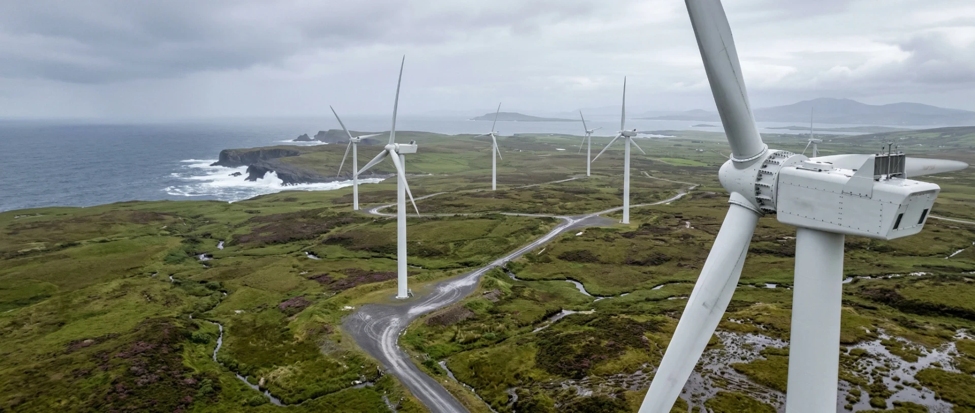
Wind Turbine Inspection AI at Scale
Ireland has targets of 9 GW onshore and 5 GW offshore wind capacity. That is a lot of blades to inspect. For operators managing annual blade inspection programmes across portfolios of 50 to 200 or more turbines, the volume of imagery compounds quickly.
A wind turbine blade inspection typically captures 500 to 800 high-resolution images per turbine. The defects are specific: leading edge erosion, surface cracks, lightning strike damage, trailing edge separation, delamination, coating degradation.
ESB uses Sterblue, a specialist automated drone inspection platform, for wind turbine blades. Sterblue reduced inspection time from 80 minutes to under 40 per turbine. It is a good product for what it does. It is a SaaS platform with its own defect classifications and report formats.
For operators whose needs fit within Sterblue's model, it works well. For operators who need to own their inspection data, define their own defect taxonomy, and deliver reports in their client's specific format, a custom system gives them that control.
One real-world inspection study found an average of 8 defects per turbine across 20 turbines, with 84% falling into three primary categories. One critical defect, a 2,100mm trailing edge separation, resulted in the turbine being taken offline immediately.
Solar and Thermal Inspection
Solar inspection is primarily thermal. Drones fly a grid pattern capturing radiometric temperature data for every panel. Common defects include hotspots, string failures, potential-induced degradation, bypass diode failures, and micro-cracks.
Drone thermal inspection covers a solar farm at roughly 10 minutes per megawatt. Manual I-V curve tracing takes 2 to 5 hours per megawatt. But the speed advantage only holds if the thermal data is processed quickly. Without automated processing, the analysis bottleneck wipes out the capture speed advantage.
For solar farms subject to IEC 62446-3, the international standard for aerial thermographic inspection of PV systems, the processing platform needs to produce reports that comply with the standard's requirements for defect classification, temperature thresholds, and documentation.
Deep Purple has not built a solar inspection system. These are the defect types a custom processing platform would handle for solar operators. The engineering is the same as grid and wind: ingest, classify, flag, report. The defect taxonomy changes. The pipeline does not.
Vegetation Management Software
Vegetation encroachment is ESB Networks' biggest annual maintenance cost. Trees growing too close to overhead lines cause outages, safety hazards, and in extreme cases, fires.
Drone imagery combined with LiDAR measures clearance between vegetation and conductors with centimetre accuracy. Vegetation management software flags sections where overhead line clearance is below threshold and prioritises the most urgent areas. The output is a prioritised vegetation management programme, not a folder of photographs.
Custom software tailored to Irish utility reporting workflows is rare. The international SaaS platforms exist but do not integrate with Irish grid operator requirements or local reporting formats.
Why Off-the-Shelf Platforms Do Not Match Irish Workflows
You do not own the defect taxonomy. SaaS platforms define the defect types. If your client has their own classification system, you are stuck with someone else's categories.
You do not own the data. Your inspection images and results live on someone else's servers. For regulated infrastructure operators, that is a real concern.
The reports do not match. Every asset owner has their own format. A SaaS platform generates its own. A custom system generates whatever your client needs.
Integration does not exist. Irish contractors use a mix of GIS, asset management, and project management tools. Off-the-shelf platforms rarely connect to ArcGIS, asset registers, or maintenance management systems like Maximo.
Pricing does not scale. Per-image SaaS pricing works for occasional use. For a contractor running hundreds of inspections monthly, a custom system is a fixed investment that does not get more expensive with volume.
When Custom Software Is Not the Right Answer
Not every drone operator needs a custom inspection platform. If you fly a handful of inspections per year, a SaaS platform like Sterblue or DroneDeploy will do the job. The economics of custom software do not work at low volumes.
If manual review takes less than a day per project, you do not have a processing bottleneck. If your client already has a platform they are happy with, build an integration layer instead. Cheaper, faster, keeps the client happy. Custom software makes sense when you are processing thousands of images per project, when your clients have specific reporting requirements, when you need to own your data, or when reporting speed is a competitive differentiator. If that is not your situation, save the money.
Processing thousands of inspection images manually? Let's look at whether automation makes sense for your operation.
How a Reusable Platform Beats One-Off Projects
The first inspection project builds the system. Every project after that uses it.
A custom inspection platform trained on your defect types, configured for your report formats, and integrated with your client's systems is a reusable asset. The model improves with every inspection as more labelled data flows through it. For a drone operator competing for framework contracts, owning a custom inspection platform is the difference between being a commodity flight service and being an inspection intelligence provider.
Operators and Asset Owners Need Different Things
Drone Operator or Inspection Contractor
If you are a drone operator or inspection contractor, you need faster processing, consistent defect classification, and reports that match your client's format. You want to own the platform so you can use it across every client.
Asset Owner
If you are an asset owner (a grid operator, wind farm owner, or solar asset manager), you need governance, audit trails, and integration with your asset register. You want defect data flowing into your maintenance management system automatically.
A custom system serves both. The operator gets processing speed. The asset owner gets structured data and integration.
For Grid Contractors: How CV Helps You Win Framework Bids
If you are bidding on ESB Networks maintenance frameworks or other grid inspection contracts under PR6, here is what matters.
Speed of reporting. Automated processing means classified condition reports ready in days, not weeks.
Consistency. Automated classification applies the same criteria to every image. Human review catches what the AI misses.
Auditability. Every classification has a traceable record: original image, GPS location, AI classification, human reviewer decision.
Scalability. Thousands of assets per year. You cannot scale manual review to match.
Data ownership. You build an asset register over time. Trends, year-on-year condition, predictive insights. More valuable than a folder of photos.
BVLOS and Why Automated Processing Matters More Than Ever
As operators navigate the IAA's Specific Category requirements and conduct SORA (Specific Operations Risk Assessment) evaluations for Beyond Visual Line of Sight operations, the volume of inspection data will increase dramatically.
A BVLOS-enabled drone can inspect an entire distribution corridor in a single automated flight. That means more data per day. Which means the processing bottleneck gets worse, not better. Operators investing in BVLOS capability need automated image processing to match. Automated reporting also strengthens the safety case for BVLOS operational authorisation by providing structured, auditable evidence of inspection quality.
What a Pilot Project Includes
Deliverables
- Custom defect taxonomy agreed with your team
- AI model trained on your inspection imagery (minimum 500 labelled images)
- Processing pipeline: ingest, classify, flag, report
- Structured report output in your client's required format
- Accuracy assessment: AI classifications vs human reviewer ground truth
- Recommendations for full deployment
Acceptance criteria (agreed before the pilot starts)
- Defect detection rate (e.g. AI flags 85%+ of defects a human reviewer identifies)
- False positive rate (e.g. fewer than 20% of flagged items are non-defects)
- Processing time (e.g. 1,000 images processed in under 2 hours)
- Report format approved by your client
Timeline: 8 to 12 weeks from data handover.
What we need from you
- Inspection images with known defects
- Your current report format and defect classification
- One or two hours per fortnight for review
What It Costs and How to Fund It
Pilot projects are scoped individually based on asset types, defect taxonomy complexity, and imagery volume.
Enterprise Ireland and LEO offer grant programmes covering 50 to 80% of the cost. The Exploring Innovation grant supports proof of concept work. The Digital Process Innovation grant supports implementation.
We handle the technical documentation for the grant application.
For a detailed guide, see our complete guide to AI grants in Ireland.
Data Sovereignty: Your Data, Your Models, Your Infrastructure
When Deep Purple builds a custom inspection system, the client owns everything. Trained models, processed data, report templates, codebase. It runs on infrastructure you control, hosted in Ireland or the EU. Your inspection data is never used to train models for other companies. If the engagement ends, everything is handed over and securely deleted.
We Have Built This Before (Different Sector, Same Engineering)
Deep Purple has a production computer vision system deployed on Irish construction sites. It processes field photographs, calculates measurements using calibration markers, and generates verified, GPS-stamped reports automatically. It works offline. It is used every day.
The engineering is the same: capturing imagery in uncontrolled conditions, processing it reliably, classifying what matters, generating structured reports. For more on how Deep Purple approaches computer vision for infrastructure and field operations, see our service page.
Is This Relevant to Your Business?
If you recognise any of these, the answer is probably yes.
- You spend more time reviewing images than capturing them
- Your clients want faster turnaround on inspection reports
- You are bidding on framework contracts where reporting speed is an evaluation criterion
- You want to own your inspection data, not rent it from a SaaS provider
This applies to drone operators, grid contractors, wind farm inspection companies, solar O&M providers, telecoms tower inspection companies, NBI contractors, bridge inspection firms, and any business that captures infrastructure imagery and needs to turn it into structured, classified reports.
Deep Purple builds custom drone inspection software for Irish drone operators, wind farm inspection companies, grid contractors, and infrastructure asset owners, processing thousands of inspection images into structured, GIS-integrated defect reports automatically.
Frequently Asked Questions
Start with a 20-Minute Conversation
No pitch, no pressure. Just an honest look at whether custom inspection software could help your operations.
Or start with a €1,000 AI Assessment →Not sure if your business is ready?
Take our free 3-minute feasibility assessment. It covers drone inspection, manufacturing, and construction. You'll get an instant readiness score with specific recommendations.
Take the AssessmentRelated Reading
About Brian Egan
Founder & CEO, Deep Purple AI Consulting
Brian Egan is the Founder and CEO of Deep Purple AI Consulting. With over 26 years in software and AI, from studying neural networks at Dublin City University, to building intelligent mobile systems for Vodafone, Nokia and Hutchison 3G, to building technology companies that delivered machine learning, computer vision and predictive AI solutions to real businesses, Brian has been building with AI technologies at every stage of their evolution.
His interest in artificial intelligence began at DCU, where he studied neural networks and pattern recognition as part of his BSc in Computer Applications. As a Marie Curie Research Fellow in Germany, he worked on EU Framework projects developing intelligent systems for integrating emerging mobile technologies with enterprise software. At Cibenix (2003 to 2011), he spent eight years designing on-device software for Vodafone, Nokia, Hutchison 3G, Sony Ericsson and other global operators, work that increasingly involved content personalisation, user behaviour analysis and adaptive delivery logic.
In 2012, Brian founded Purpledecks, a software consultancy that incorporated machine learning, computer vision, data classification, predictive features and recommendation engines into client projects years before the current generative AI wave. From Purpledecks came Hype4 (UX research including AI-powered biometric identification for government programmes) and Reactable AI, an autonomous AI marketing platform built internally by the Deep Purple team, funded by Enterprise Ireland's Pre-Seed Start Fund, with 600+ users and paying customers across five continents.
A former Marie Curie Research Fellow, Brian leads Deep Purple's work with established businesses across Ireland, the UK, the EU, and the US, helping them identify where AI delivers genuine commercial value and guiding them from first assessment through to working system.
Deep Purple AI Consulting (deeppurple.ai) is an AI consultancy and custom software development company based in Longford, Ireland, serving clients across Ireland, the UK, the EU, and the US. We help established businesses identify where AI can make a real difference, then build the systems to make it happen. Senior-led delivery. Grant-funded where possible. No hype.